

Addis Ababa, Ethiopia: Some 60 million people are under weather alerts across 30 states, with snowfall in Kansas and northern Missouri predicted to reach as high as 35.6cm.
Heavy Snowfall Across US
Road conditions have become increasingly dangerous in the central US since Saturday, with snow in the most heavily affected regions – Kansas and northern Missouri – predicted to reach as high as 35.6cm.
Some 60 million people are under weather alerts across 30 states, with the National Weather Service warning that severe thunderstorms, with the possibility of tornadoes and hail, are also a possibility in some regions over the next few days.
Kansas, Arkansas, Kentucky and Virginia have declared states of emergency as the storm, driven by a polar vortex, moves east.
A polar vortex is an area of low pressure and cold air that swirls like a wheel around each of Earth’s two polar regions. Sometimes the Arctic polar vortex wobbles and a lobe surges south, blanketing parts of North America with bitter temperatures.
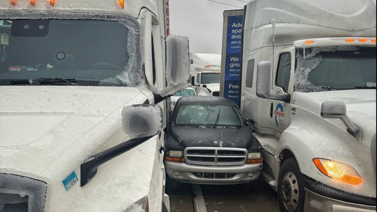
It has already led to accidents across the nation, with a fire truck, several tractor-trailers and passenger vehicles overturned west of Salina, Kansas, on Saturday, and some trucks spiralled into ditches, state highway patrol trooper Ben Gardner said.
“We are in it now,” he said in a video on social media which showed him at the scene of an accident.
To demonstrate the danger on the roads, the trooper filmed himself running onto the seemingly clear road and sliding across it for several seconds due to what appeared to be black ice.
“That’s what we’re dealing with out here, and it’s not getting better, it’s getting worse, so get off the roads,” he warned.
Temperatures were well below zero in many areas on Saturday, such as -7C to -10C in Chicago, -18C in Minneapolis, and -25C in International Falls, Minnesota, on the Canadian border.
Freezing rain in Wichita, Kansas, led to multiple crashes on Saturday morning, authorities said, as they urged drivers to stay home if possible and watch out for emergency vehicles.
States of emergency declared due to major winter storm
Governors in neighbouring Missouri and nearby Arkansas declared states of emergency, while snowy conditions threatened to make driving dangerous to impossible, forecasters warned.
“Please stay off the roads. Crews are seeing too many vehicles out and sliding off,” Missouri’s transportation department said on the social platform X.
Major airlines, including American, Delta, Southwest, and United, are waiving change fees ahead of likely flight disruptions in heavily affected regions.
Temperatures were well below zero in many areas on Saturday, such as -7C to -10C in Chicago, -18C in Minneapolis, and -25C in International Falls, Minnesota, on the Canadian border. (Sky News)
Travel disruptions
Over 1,200 flights within, into and out of the United States have been delayed and more than 750 had been canceled as of Sunday morning, according to FlightAware.com. The most affected airports include Kansas City International, where almost 190 flights have been canceled, and St. Louis Lambert International Airport, which has had over 190 cancellations.
Chicago O’Hare International Airport had 120 cancellations and over 60 delays. Southwest Airlines accounted for most of the cancellations and delays, with over 230 flights canceled and 250 delayed Sunday morning.
Kansas City International Airport briefly closed Saturday as crews cleared runways — delaying dozens of flights, including a charter jet transporting the Kansas City Chiefs, according to The Associated Press.
And an 18-mile stretch of Interstate 70 in Kansas was shut down as blizzard conditions threatened up to 14 inches of snow and 40 mph wind gusts, with warnings in effect until early Sunday, according to the National Weather Service.
The weather service predicts historic precipitation for parts of Kansas and Missouri, forecasting over 15 inches of snow from northeastern Kansas into north-central Missouri — the region’s heaviest snow in a decade.
The weather service warned of “considerable disruptions to daily life,” including “dangerous or impossible driving conditions and widespread closures,” making travel “very difficult to impossible” through Sunday.
Cincinnati, Chicago and St. Louis treated roads in advance of the storm and prepared warming centers.
Scattered snow showers developed across the northern Plains on Saturday afternoon and through the evening. More than 2 million people were covered by a blizzard warning for most of Kansas and a large part of Missouri on Sunday morning, according to the weather service.
Such a warning alerts residents to a likelihood of reduced visibility of a quarter-mile or less and sustained winds of at least 35 mph.
Sunday was expected to bring a severe weather risk across the lower Mississippi Valley, putting 7 million people at risk for tornadoes, damaging wind and hail in Jackson, Mississippi, and Baton Rouge, Shreveport and Lake Charles, Louisiana, among other cities.
As the storm advances east, millions more people were bracing for record low temperatures, forecasters warn.
Snow will arrive in the mid-Atlantic and the central Appalachians overnight into Monday morning. The showers will linger through Monday, ending by Tuesday morning as the system moves offshore.
Washington, D.C., Baltimore and Philadelphia were among the major cities preparing for snowy and icy conditions from Sunday into Monday, with parts of Virginia expecting 5 to 12 inches of snow.
Meanwhile, severe thunderstorms could hit Southern states unaccustomed to severe cold, including Arkansas, Louisiana and Mississippi.
From coast to coast Saturday, weather-related flight delays were estimated at almost 7,000.
At the western end of the low-pressure system, Denver International Airport led the globe in delayed flights, with nearly half its departures Saturday leaving late, according to FlightAware.com.
Major airlines, including American, Delta, Southwest and United, are waiving change fees ahead of likely flight disruptions.
In the wake of the system, a significant drop in temperatures is expected for the eastern two-thirds of the country. Highs will drop 10 to 25 degrees below average starting Sunday through Friday. Highs will range from the single digits and the teens across the Plains and the Midwest, to the 20s to 30s in the mid-Atlantic and the Northeast.
The most extreme temperatures will be in the northern Plains, where overnight lows will dip as low as minus 20, with wind chill values around minus 40. Cold weather advisories are in effect from eastern Montana through Minnesota.